Map of Kagera with quake prone areas ready: minister

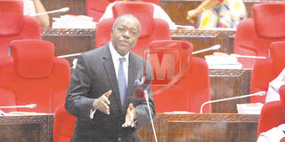
The minister of Energy and Minerals, Prof Sospeter Muhongo, responds to questions from the MPs in the Parliament in Dodoma yesterday.
PHOTO | ANTHONY SIAME
What you need to know:
- According to Prof Muhongo, the map is one of the three scientific documents prepared by the Geological Society of Tanzania (GST), following last September’s earthquake in the region, which aims at minimising future impacts.
Dodoma. The minister of Energy and Minerals, Prof Sospeter Muhongo, yesterday told the Parliament that the government has already published a map of Kagera Region, indicating all earthquake prone areas that should be avoided.
According to Prof Muhongo, the map is one of the three scientific documents prepared by the Geological Society of Tanzania (GST), following last September’s earthquake in the region, which aims at minimising future impacts.
The minister was responding to Mr Wilfred Lwakatare (Kagera Urban-Chadema), who sought Speaker Job Ndugai’s guidance, claiming that his voters were living in fear after a minor earthquake, which hit the region on Saturday and the government was yet to issue a geological report since the September earthquake, a situation, which left them in a difficult situation.
“People are sleeping outside their houses since Saturday. They don’t know what to expect. There is neither official nor scientific report from the government,” said Mr Lwakatare.
According to Prof Muhongo, the last of the three reports was to be presented to Kagera Region’s security committee by officials from GST. However, the authorities in the region insisted that they wanted it presented by the GST Chief Executive, Prof Abdulkarim Mruma.
“Prof Mruma and his team are waiting for another appointment to present the report. I have the report here with me and I will share it with Mr Lwakatare later. It is a very detailed report. Apart from preparing the three reports, we have also set the biggest detection centre in the region, which goes down up to 10km. Other stations in the country can only go down to three kilometres only,” he said.
Prof Muhongo, however, noted that, as of now there was no one in the world with precise knowledge of detecting, where and, when an earthquake would occur.
“What we can so far detect are prone areas. We have completed that task in Kagera and we ask the people to avoid all listed areas. We are doing the same for Dodoma,” said Prof Muhongo.


