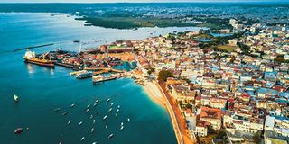
Unguja. Zanzibar has launched an aerial land surveying project aimed at resolving land disputes, improving land administration and boosting investor confidence in the islands.
The Zanzibar Land Administration and Registration Information System (LARIS) project is expected to improve the business environment, increase government revenue, enable citizens to access loans using land rights certificates as collateral and support the development of modern cities and better housing.
The project will use a specialised aircraft to collect and process land information in nine areas, with 25,000 plots expected to be surveyed.
Speaking during the launch of the project at Nungwi Airport in North Unguja, President Hussein Mwinyi said the initiative marked a major step in reforms to improve land governance and management.
His speech was delivered by Second Vice President Hemed Suleiman Abdulla.
“Through this project, we expect to significantly improve land-use planning, surveying, identification and digital registration of land,” Dr Mwinyi said.
The project, which will cost €37.4 million (about Sh115 billion), will involve aerial photography, preparation of base maps, construction of a National Land Information Centre and establishment of service centres in Unguja and Pemba.
It will also include preparation of land-use plans, digitisation of existing map records and development of an electronic system for storing and managing land information.
Dr Mwinyi said the existing land information system relies on outdated methods that contribute to delays in service delivery, lack of accurate data and increased disputes over land ownership, boundaries and usage.
He said many land services are still provided at a limited number of government offices in town, forcing citizens to spend more time and money seeking assistance.
“As a result, some citizens make informal decisions that increase disputes and lead to unplanned use of land,” he said.
Dr Mwinyi said the government had taken deliberate steps to strengthen land administration, including improving land policies and laws and introducing LARIS to address existing challenges.
He said the current system makes it difficult to obtain timely and accurate information on land allocated for residential areas, agriculture, industries, investment and conservation.
The President thanked the French government for supporting the involvement of IGNFI, a French company implementing the project, as well as the French Public Investment Bank (BPI) and CRDB Bank for financing the initiative.
However, he said technology alone would not deliver the expected results without proper use and commitment to serving society.
Giving technical details, Land Commission Executive Secretary Mussa Kombo Bakari said the project would run for two years and cover the surveying of 25,000 plots.
He said the LARIS agreement was signed on August 7, 2024 between the Ministry of Lands and Housing Development and IGNFI.
Implementation, however, was delayed as the project awaited completion of financial agreements, which were signed on October 27, 2025 between the Ministry of Finance, CRDB Bank and BPI.
Mr Bakari said the project would cost €37.4 million excluding VAT and €43.117 million including VAT. It will involve 24 months of implementation, followed by another 24 months of maintenance and development of the land information system.
“The aircraft will spend three months capturing aerial images, with about 36 hours of flying time, depending on airspace approvals,” he said.
North Unguja Regional Commissioner Gallos Nyimbo said residents had been adequately involved and were ready to support the project, which he said would address long-standing land challenges.
Lands and Housing Development Minister Rahma Kassim Ali said the project was an innovation that would transform land planning and surveying in Zanzibar.
“The project has many benefits, including reducing disputes. Land use will be properly planned and investors will have confidence because they also sometimes find themselves involved in land disputes,” she said.
She said only 20 percent of Zanzibar’s land has so far been surveyed.
Register to begin your journey to our premium contentSubscribe for full access to premium content