But questions remain: are the residents of the district town and villages around the towering mountain safe from a similar catastrophe?
"We appreciate the support we got after the disaster, but we are not convinced of its cause," said an elder, Mathew Sedoyeka.
The retired government official said more remains to be told about the December 3 calamity, which has never been experienced in the area in recent times.
He said, although he was not challenging the experts, residents of the affected areas have different versions of the likely cause.
Geological experts, in their preliminary report, said the killer floods could have been triggered by pressure on rain-soaked terrain following heavy rains.
However, Mr Sedoyeka and other residents of the area who spoke to The Citizen over the weekend said there could have been more than the disintegration of rocks.
"Almost everybody near the mountain says they heard a loud bang before water cascaded down with mud, huge rocks and logs," he said.
"What could have been this loud bang—a seismic or tectonic movement or something closer to it? What exactly caused that?" he asked.
Mr Sedoyeka, who served as district commissioner for many years, recalled a suggestion made in the early 1960s on the Katesh master plan.
In those years, at least two permanent rivers cut through the present-day town, although only trickles of water remained in the dry season.
"It was suggested that there should not be any construction near the river beds. Nobody heeded that directive, and construction went on," he said.
Lazaro Samhenda echoed but distanced himself from the volcanic eruption narrative, saying the calamity could have been avoided if people did not settle in the natural waterways.
"From my knowledge, it was a landslide caused by water resulting from environmental destruction, especially on the Gendabi side," he said.
Gendabi, about 30 kilometres from Katesh, was also hit by the disaster when the killer flash floods cascaded down the mountain on the fateful day.
On the Katesh side, Mr Samhenda attributed the tragedy to "negligence by people who constructed houses on the natural water paths."
Gidamis Shahanga, a former top national athlete who lives in Jarodom, one of the hardest-hit villages, said the Hanang calamity is a bitter memory.
Jarodom is close to the Hanang forest margin and is believed to be where the flash floods started in the wee hours of December 3.
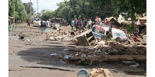
But as life was returning to normal at Katesh, huge rocks continued to remain solid within where the full force of water and mud took them.
This was more evident near the Lutheran Church, a few metres from the Babati-Singida road, where many shops and business kiosks were swept away.
The food market on the western side of the town has been closed for business and major repairs are underway.
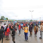
In recent days, business people whose premises were destroyed by floods and mudslides have been appealing to the government to bail them out.
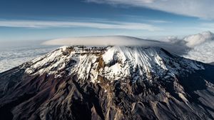
Tour guides who scaled the 3,240-meter-high mountain shortly after the tragedy witnessed the impact of the killer avalanche on the terrain.
"We have seen where the raging waters would have started, bringing down huge rocks and logs," said one of them, Mathew Darema.
They organised the expedition to see if the mountain was safe for climbing after the recent calamity.
The trip was also intended to counter reports, which circulated widely on social media, that there was a volcanic eruption that triggered the killer floods.
They said they did not encounter the raging waters, cascading rocks, and logs that created much havoc on December 3rd.
"Instead, we saw the impact created by the mudslide on the mountain slopes, knocking down the trees," he said.
Mt Hanang, the fourth highest in Tanzania, attracts about 400 climbers a year, many of them foreign tourists.
Up to 2,000 locals, including schoolchildren and residents of the townships, often climb its slopes for fun.
Mr Darema, who operates his tour business in Arusha, hails from Jarodom village, which lost over a dozen people in the killer floods.
The village on the foothills of the mountain is believed to be where the tragedy began following the disintegration of rocks that triggered the avalanche.
Strong waves of water and mud carrying huge rocks knocked down houses along the natural waterway in the vicinity, all the way to Katesh town, creating never-seen havoc.
However, another member of yesterday's expedition team, Thomas Safari, said the avalanche could have begun at higher altitudes.
"We saw how the fragile soils and rocks high up on the mountain have been impacted by what we believed to be the December 3rd rains," he said.
"Now we can tell the world that Mt Hanang is safe for climbing," added the tour guide, who coordinates mountain climbing from Arusha.
Mt Hanang, an oasis in the generally drought-prone Hanang plains, has in recent years been promoted for tourism.
Its potential manifests in hiking, walking safaris, and cultural tourism, which are located in the heart of the indigenous communities.
A few years ago, it was elevated to a nature reserve under the Tanzania Forest Service (TFS) in order to enhance both conservation and tourism.
TFS, a state-run agency established in 2009, has a total of 462 natural forest reserves and 23 plantations under its care across the country.
In 2015, about 100 foreign tourists climbed the mountain, according to statistics. Its nature reserve alone covers 5,871 hectares.