How farming, logging push Kilombero wetlands to ruin
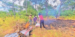
Conservation officers burn charcoal seized in Iruma, Kilombero District, Morogoro Region, one of the areas affected by human-induced environmental degradation. PHOTO | IMANI MAKONGORO
Morogoro. “We never knew that farming here means destroying a water source.”
That reflection by residents of Lumemo Ward in Ifakara Town Council captures growing recognition that years of unregulated farming, brick-making, tree cutting and charcoal burning within wetlands have contributed to environmental degradation in the Kilombero River Basin.
An investigation carried out by The Citizen shows that limited awareness of wetland conservation has significantly driven the deterioration of one of Tanzania’s most important ecological zones, which supports food production and feeds water systems linked to the Julius Nyerere Hydropower Project (JNHPP).
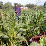
In Lumemo, residents say they have long cultivated up to water sources during the dry season, following soil moisture without understanding the impact on wetlands’ ability to store and gradually release water.
An elderly resident of Kibaoni, Mr Kassim Makua, recalls the 2026 floods, saying he never imagined human activity could trigger such destruction.
“Have you ever seen water coming like a mountain? That is what happened here,” he says, describing how people survived by climbing trees and rooftops as livestock, crops, and property were swept away.
Mr Makua says the floods were followed by a cholera outbreak. “The floods destroyed toilets, faecal waste floated in settlements, and rainwater mixed with sewage.”
“Here in Lumemo, we keep livestock, farm, make bricks, and burn charcoal. Floods and cholera have set us back in our daily activities,” he adds.
He notes that farming is practised almost year-round due to persistently moist soils.
“We had never experienced floods like these. Normally, they are mild, but this time they were extreme,” says another elder, Mr Juma Msamiri.
The problem is not confined to older residents.
A 21-year-old, Ms Warda Mponda, says she has never received education on wetland conservation or farming impacts in catchment areas. As a result, activities have expanded into wetlands, including farming, livestock grazing, brick-making, tree cutting, and charcoal burning.
Some residents also dispose of agricultural input packaging indiscriminately, with waste ending up in rivers.
Ifakara Town Council environmental officer, Ms Salome Mahenga, says improper disposal contributes to loss of aquatic life and increases disease risks.
A farmer in Mang’ula, identified as Asenga, says he is unaware of safe disposal methods.
“I throw them at the edge of my farm. I have nowhere else to dispose of them,” he says.
Another farmer, Mr Nathaniel Matinyi, says waste collection points are too far: “Most of us end up dumping waste in the fields.”
Visible impacts
Ms Mahenga says wetland destruction has caused some rivers to change course while others have dried up.
Once wetlands are encroached upon, she says, they lose their capacity to absorb and store water, worsening floods and dry-season shortages.
“Lumemo is also affected by cholera because many people lack toilets, and those who have them open them during the rainy season, allowing sewage to flow into water sources,” she says.
She adds that human activities in catchment areas have caused many rivers to disappear or lose their natural flow.
An investigation shows the problem extends to Iruma, Mang’ula, and Ndenje, where farming in wetlands, livestock grazing along riverbanks, and tree cutting continue.
The result has been reduced river depth, disappearing streams, and rising pollution.
“I arrived in Kilombero in 1998. There were 38 rivers, but now many have lost their flow or dried up,” says Ms Mahenga.
Hydrology technician at the Rufiji Basin Water Board, Mr Gerald Hamisi, says the impacts extend beyond Kilombero.
He explains that the Kilombero River contributes about 62 percent of the water entering the Rufiji Basin, which feeds the JNHPP.
“Kilombero is the water heart of the Rufiji Basin. If we destroy its wetlands, impacts will affect communities and electricity generation,” he says.
He adds that natural vegetation must be preserved to maintain moisture and stable flows.
Mr Hamisi notes that the Rufiji Basin spans 34 districts across 10 regions, covering about 20 percent of Tanzania’s river basins, making it the largest drainage system.
Register to begin your journey to our premium contentSubscribe for full access to premium content